
|
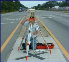
Trimble Rover GPS Receiver Setup for RTK Surveys |
|
RTK surveys Survey Method |
|
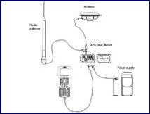
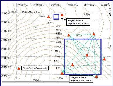
Plot of geoid undulation contours over a local survey area (Leica) |


|
GPS RTK Topographic Procedures Approved Florida Board of Professional Surveyors and Mappers – Course No. 7592
Course Description:This correspondence course gives instruction and information regarding Real Time Kinematic Global Positioning System surveying techniques used in the collection of topographic data. The course teaches skills needed in the practice of this modern surveying and mapping procedure. The course study materials consist 14 typed pages found in Chapter 9 (GPS Real Time Kinematic Topographic Survey Procedures) of the Department of the Army publication (EM 1110-1-1005) dated January 1, 2007, by the U.S. Army Corps of Engineers entitled “Engineering and Design Control and Topographic Surveying”.
· RTK Survey Procedures · RTK Survey Accuracy · Site Calibration · RTK Systems Checks · Data Collection
Course Objectives: The objective of “GPS RTK Topographic Procedures” is to provide information that will assist the surveyor in using GPS Real Time Kinematic surveying techniques in preparing topographic surveys.
Evaluation Method: A ten question written examination will be used to determine if the course objectives have been met. The student must achieve a minimum of 70 percent correct answers in order to receive Land Pro Seminars’ Continuing Education Credit Certification.
Course Outline
1. Purpose and Scope 2. RTK Field Techniques · Ambiguity resolution · Survey procedure · Accuracy of RTK surveys · General data collection operation · Receiver set up 3. Standard RTK Observing Procedures 4. Site Calibration 5. RTK Survey Field Data Collection Procedures and Checks · RTK system check · RTK measurements 6. Guidance for Setting Construction Control Points Using RTK Technique · RTK survey design · Satellite geometry · Field procedures · Office procedures
|